
Flagger Force
A Suite of Custom Geospatial Applications to Streamline Manual Business Processes
The Solution
Seisan developed an automated tracking system utilizing in-vehicle GPS coupled with a user-friendly dashboard to monitor and display real-time statuses and enable quick resolution to issues in the field.
About the Project
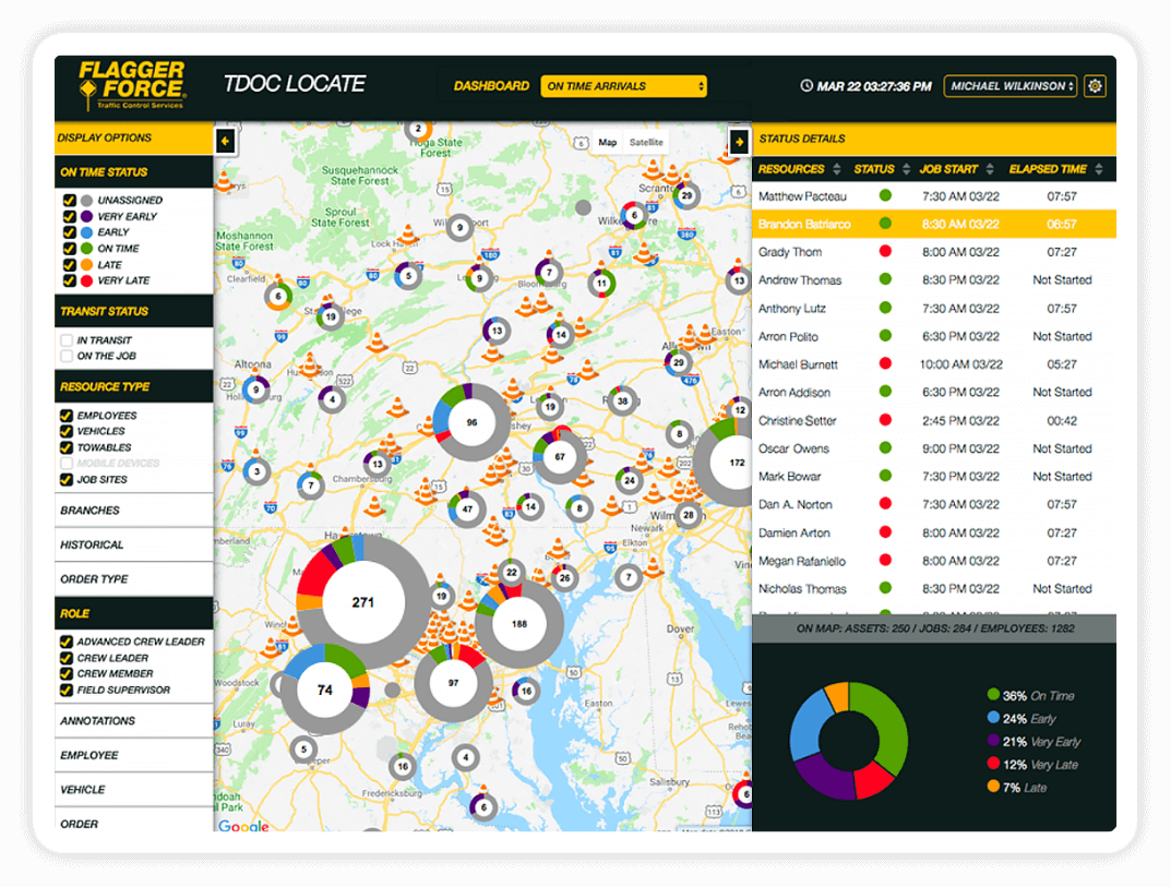
The shining star of this software show is TDOC Locate – a custom application suite that we created for Flagger Force to enable automated tracking and real-time monitoring of its location-based assets in the field.
More than mere monitoring, TDOC Locate boasts a user-friendly dashboard interface that features an interactive map UI (built on the Google Maps infrastructure) allowing users to quickly access vital information ranging from truck locations – including who “owns” that truck, their contact information, truck specifications and capabilities – on down to which employees were picked up for that particular assignment.
A variety of filters allow users to create custom map views to highlight specific data sets like time status, branch-specificity or resource and order type. Historical inquiries and search capabilities were also instituted to allow users to check past statuses when needed.
Since deployment to all branches in Q1 of 2017, TDOC Locate has delivered improvements in safety with over 93% of employees arriving to site on time.
Filters & Clustering
Users can filter by On Time Status, Resource Type, Historical Data, and other options in order to create the display that works best for them. Assets are grouped into color-coded clusters as users zoom out of the map display.
Leveraged Technologies
Microsoft Azure Functions
MS SQL Server (Azure managed)
Microsoft Service Bus
Microsoft Application Insights
Microsoft Entity Framework
Google Map API
Platform Integrations
GPSInsights
Internal Order System
Core Capabilities
Geospatial
Big Data
IoT Data Streaming
Cloud (Azure)
UX/UI
Systems Integration
- © 2022. Seisan Consulting, LLC
- Terms and Conditions
- Privacy Policy

